By: Prabir Kumar Talukdar
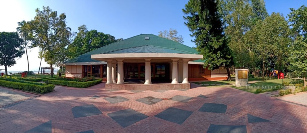
If you are a resident of Guwahati, the Panbazar bus stop isn’t new to you. If you’ve ever been to Guwahati as a tourist, chances are you’ve passed through this stop on your way to Kamakhya Temple or the airport, as it’s located on the city’s arterial thoroughfare, the Mahatma Gandhi Road. One of the highlights of this area is the fruit bat colony–possibly one of the largest in this part of the world. If you are here after sunset when the sky turns into a majestic hue of dark blue, the screeches of these Indian flying foxes are almost unmissable. However, there are no written records of the origin of this colony. A few steps toward the west lies the Sukreswar Temple. In front of the bus stop, there is a small alley that leads to the Mahabahu Brahmaputra River Heritage Centre, which opened in October 2021. On its right lay the ruins of the erstwhile residence of the Superintendent of Police. Apart from these, there isn’t much to look around for an unobservant eye. But for someone who loves to peek into the city’s past, this area of Panbazar Water Tank can sum up much of Guwahati’s last 400-year-old history. The question is–how?
During my growing up years, I, along with my parents, used to travel to our maternal village, Suwalkuchi, 40 km from our residence in Hatigarh, east of Guwahati. My father had a Kinetic Honda scooter, on which we three used to travel quite comfortably until I was around 11-year-old when I no longer could fit in between my parents. During our ride, there were two very clear mild slopes that we had to cross: one was right at the Guwahati Club roundabout, and the second one was just after crossing the Panbazar bus stop. Over the years, the development of roads has levelled the slope at the Guwahati Club area. The second slope starts right at the front of Panbazar Adarsha Vidyalaya and goes on till Northbrook Gate is still there, but its ascent-descent has greatly reduced because of constant repairment. Last year, after I was done visiting the Heritage Centre on its inauguration day, I decided to walk a few kilometers down the road towards the Fancy Bazaar Ferry ghat. During my walk and after reviewing the pictures from that day, there were a series of certain questions that had started to trouble me. One, why is there a slope in the first place? Second, does the mound behind the bus stop have anything to do with the slope? Third, what was there earlier before the Government decided to build the municipality water supply treatment plant?
To search for the answers, we need to turn the clock back at least 410 years. The year 1617 was crucial in many aspects. Pandu, a port and strategic outpost was overrun by the Mughal army in 1615 after defeating the Koch. To counter the Mughal’s incessant aggression, Ahom king Swargadeo Pratap Singha initiated two brilliant measures in the year 1616. He put Balinarayan, brother of the Koch king Parikhit Narayan, as the king of a tributary state, Darrang, and brought the whole under Ahom’s suzerainty. Next, he immediately passed an order to shift the Sadar (headquarter) of Borphukan from Koliabar to Guwahati. In 1617, Borphukan’s hawli first came up near the present-day Jur Phukhuri. Later, it was shifted to Fancy Bazar and finally, it stood for more than a hundred years on the Itakhuli hillock where the present Heritage Centre stands. The mansion (Hawli, in Assamese) was far from being grand: it was a simpler structure constructed with straw, thatch, and bamboo. Itakhuli within a short span turned into a military command zone.
Who built the first fort on the Itakhuli mound is still debated, but based on the records; we can assume it was the Ahom who built the first ‘Koth’ right after Guwahati came under the jurisdiction of Borphukan. ‘Koth’ (Ahom) and ‘Qila’ (Mughal) are two terms mentioned synonymously in historical records according to the rulers who ruled over Itakhuli. In 1659, Prince Aurangzeb ascended the throne of Delhi. He immediately issued a Farman, entrusting his most able commander, Mir Jumla, to invade Kamrup and put an end to the unrest once and for all. By the end of 1662, Mir Jumla was already knocking at the doors of Saraighat. The then Guwahati’s Borphukan, Chengmun Namoniyal Rajaxahur, immediately left the Itakhuli outpost and allowed the Mussulmans to capture it unchallenged. The ‘Koth’ now turned into a ‘Qila.’ But this fort was unlike any other form of Northern India. Mughals never turned it into a concrete complex; instead, they let the original bamboo structure float for the time being and barricaded it with impenetrable security. On the north of Itakhuli, the mound ends into a cliff that drops directly to the river Brahmaputra.
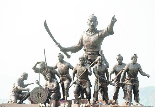
However, in the 17th century, the course of the river was a little different from what it is now. There was a considerable distance between the base of the cliff and the river, which was purposely used as an advantage by Lachit Borphukan, who ordered his army to conduct a night raid at Itakhuli in September 1667. The first battle of Itakhuli was a strategic victory for the Ahoms, and it lifted Lachit Borphukan to an almost mythical stature among his countrymen. Words of this triumph were later inscribed on a stone at Kanai Barakhi in North Guwahati. From 1679 to 1682, Ahom lost their control over Guwahati until Swargadeo Gadadhar Singha led a strong contingent with his commander, Dihingia Alun Borbarua, and took back Itakhuli along with the rest of lower Assam from the hands of the Mughal. This was the second battle of Itakhuli and it proved to be the final confrontation between the Ahoms and the Mughals.
Itakhuli’s boundary stretched from Sukreswar to Latashil and further up to the foothill of Nabagraha. However, the radius of the mound covered only a kilometer toward the east and down south. If we must make an analysis based on the photographs and physical observations of the mound, we can posit that the slope exists because it was a part of the medieval road, which connected the outer boundary of the Itakhuli (Latakhil Choki) to Pandu. If we observe the mound on the north side, behind the bus stop, we would notice a vertical slope, which is not a result of natural weathering. On the south, where the present-day Panbazar sits, the mound is perhaps levelled out with time. This interpretation can also be made by simply observing the footpath on both sides of the road. A very mild descent can also be observed to the south of Panbazar if we continue to move on the Jaswanta road.
According to historian Kumudeswar Hazarika, the Assam Government installed the water treatment plant in Panbazar in 1962. Before that, it was a public park that hosted and stood witness to fiery speeches of many stalwarts of the Indian freedom struggle from Mahatma Gandhi, Rabindranath Tagore, Subhas Chandra Bose, Swami Vivekananda to Tarun Ram Phukan, Gopinath Bordoloi, Nabin Chandra Bordoloi, and others. In the early 19th century, the British purchased this barren land from a Bengali contractor, Babu Nabagopal Banerjee. Their idea was to create a space where they could organize the upcoming Golden Jubilee Celebration of Queen Victoria’s ascension to the throne, in June 1887. Consequently, the public park from thereon was named Jubilee Garden.
The medieval road didn’t lose its importance during the British Raj. The pavement from Bharalu Bridge to Latakhil was named Strand Road. From Latakhil to now Governor’s house, it was Upper Strand Road. The name remained unchanged for a long time until it was decided to rename the complete stretch of Mahatma Gandhi Road. The present slope is approximately 5ft (1.52 m) above what it was 20 years back. With the coming of the British–who inherited an almost dead city, after it was razed to the ground by the Burmese–Itakhuli and its surroundings slowly transformed into an administration hub. For many years, the mound remained hidden from the city dwellers. The 150-year-old bungalow that was the residence of the Deputy Commissioner in pre-and post-independent India was renovated and transformed into the present-day Mahabahu Brahmaputra River Heritage Centre. Now, the complex at least provides the new generation of Assamese with an opportunity to put their feet and stand on a piece of land where our forefathers displayed an array of ineffable valour and sacrifice.


